Spatial Networks, Urban Tech and Digital Urbanism
This is the combination of a couple of talks I’ve given in the last few months to the ULI Urban Tech Committee and the Academy of Urbanism Digital Urbanism groups.
Urban Tech is something that has developed a lot in the last 10 years and which now seems to have a lot of interest and attention. There are a lot of terms – Future Cities, Smart Cities, Prop Tech, Urban Tech, etc – which are all slightly related but not quite connected in the way they could be.
One way of trying to understand how they fit together is by tracing what has changed in this time and what this means for the way we interact with cities.
While its interesting to see how things have changed, what is possibly more important, as professionals who work with, and in the context of cities, is to ask the more difficult “so what” questions of why things should change?
Here’s an outline of the reasons Why that will be explained in more detail below:
- Better outcomes for cities and people
- Creating benefits between public and private sectors in the short and long terms
- More transparent and inclusive decision-making
- Crossing siloes between planning and service delivery for more effective and efficient spending
10 years is a personal starting point; it was in 2006 that I joined Space Syntax. In that time there has been lots of incremental change that adds up to create a completely different environment for urban tech:
- On the technical side, there is Open Data, Open Source Software, better processors, and data management. People are more aware of modelling and simulation.
- On the consumer side, smart phones are now an essential to almost everyone, and this has meant that there are a huge number of Apps available that provide user-friendly interfaces to services, tailored to your personalised data.
- On the political and economic side there is a clear strand of thinking on the value of cities. There is also Brexit, which means looking at a (geographically) larger export markets and towards countries with growing populations – and everyone is aware of how large the forecast numbers for global urban population are and how many new cities this means.
So there’s now technical capability, a general awareness of issues, and a huge market.
Urban Tech is a big definition, and to help position things within this environment its useful to think about how they fit in to three general urban cycles: planning and policy; design and development, and; operation and management.
These cycles also apply to different scales from the Region to the City to the Building.
To apply technology to an urban context, we have to understand what the urban context is, and why it is the way it is:
Cities are essentially places that allow people to live in close proximity to many opportunities simultaneously – these may be social, economic or both. There is lots of research on agglomeration benefits and the effect of city size (in terms of population) on outcomes.
What is critical to providing these opportunities are the streets and public spaces that form a skeleton for people to move through and to come in to contact with each other, with events and with goods. Streets are the essential technology of cities.
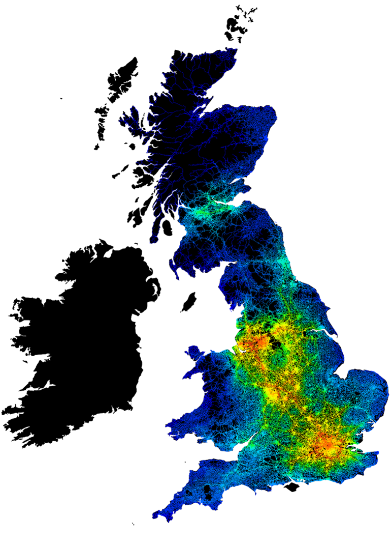
Cities are big networks of space that create more opportunities for interaction and technology allows these networks to be modelled and analysed to see where activities are more likely to happen (this is space syntax).
Through both academic research and real world application, the way the spatial network is structured has been found to influence and relate to patterns of movement, landuse distribution, value distirbution and crime.
So the spatial network is influential on outcomes, but more importantly, we’re also locked in to it: it is often the first part of a city that emerges; it carries infrastructure networks and utilities, and worse; changing it requires adapting land ownership which is slow, expensive, disruptive and sensitive to individual will.
Because of these reasons, the spatial network needs to be considered and understood through every stage of the urban cycle.
The spatial network can be modelled on its own, analysed and interpreted, and this will explain a lot about how the city works at different scales. Things like where the major centres and sub centres are, and where movement is likely to be.
Because of the advances in technology and availability of new (open) data, its now possible to make more complicated models that start to take account of other urban systems beyond just the spatial network.
To do this it means linking between datasets on People, Urban Form, Resource and the Environment. But just because you can make something more complicated doesnt mean it will be better.
However, by linking these things to the spatial network, it allows new analyses to be produced, which are more simple, need less interpretation, and which can be explained in terms that an untrained person can understand more easily.
Instead of hierarchies of centres, or streets – which are understood in a professional context but maybe less well outside of these groups – its possible to talk about the number of employment opportunities within half an hour, or the numer of schools or other services people can access from every house.
And these services can be described more precisely, for example all the practices where Doctor:Patient ratios meet certain criteria. And measures of quality, such as patient satisfaction can be added to this. This makes it possible to categorise every house in a city according to the choice of GPs within a 15 minute journey (by any mode of trasport), that have a high doctor:patient ratio, and high patient satisfaction levels. And this is all possible from open data.
But key to this is to link the data, and using the spatial network to do this is the beginning of a standard way to represent and link different data.
This can work across datasets, including lines, points, boundaries, open, paid and private. If it can be linked to a property it can be linked to the spatial network. Property to property by itself is misleading, because it ignores the fundamental infrastructure of a city – the Street – which has developed over thousands of years around people, how they move and what they can see.
There are also elements that dont necessarily need to be spatially connected – such as social networks, however if people can be assigned to property there is the potential to link between spatial and non-spatial networks.
So linking back to the start of this, its now possible to make models on a much larger scale and anlyse them more quickly. It means a model of the UK could be processed once for example, then a set of pre-calculated queries or standard reports pulled out.
In turn what this means is that what was a bespoke piece of research or consultancy limited to larger planning and design projects, can now become more standardised, and with that a more integral part of smaller projects and service delivery.
For example, if the physical infrastructure creates a series of constraints and opportunities, identifying what and where these are creates the potential for a number of responses: policies to change behaviour can be targeted at certain parts of the city; delivery of Services can be prioritised in some parts of a city where access is less good; affordable housing can be located in places where its not essential to have access to private vehicle transport, or; cities can be grown taking these systems in to consideration.
Because space and property and people can be combined with other datasets it starts to provide an integrated, but accessible, starting point for designers, city administrations and stakeholders. It also provides a mechanism for longitudinal analysis, enabling the link between planing and design decisions and their outcomes to be understood more objectively.
One of the conversations in developing this thinking has been how there are very distinct differences between Prop Tech, Smart Cities, Future Cities, and BIM etc, but that if the data collected through each of these sectors could be structured and accessed in the right way, then what is often collected to generate a benefit in terms of short term revenue, could be used to improve the long term outcomes in a city. This generates benefit to everyone in cities.
Technology has the potential to create a common link to work across the siloes present in each of the urban cycles defined earlier. However, the risk is that because there is an even higher barrier to access the core techchnology, essentially the code, it could also create new siloes. Even worse, if decisions are essentially made through software code, the basis for these decisions could become completely inaccessible.
Technology only works when it works for people. Where it doesnt, it hasn’t taken off. Cities are systems developed over hundreds of years to provide access to human interaction, and the way the spatial network fits together enables this. For this reason any application of new technology to cities has to consider the spatial network.
Image (C) Space Syntax 2014, using OS Open Data
Text, Ed Parham
