Why we should be planning future cities for people not technologies

Often conversations about the future of cities include the impact of new technology, and assume that the cities of tomorrow will be completely different. However looking back through a history of future cities we can see this is misleading.
Technology provides an interesting starting point though, it helps identify trends and it means we have to keep asking questions about cities; why society needs them, what they do, how they work, and also whether x new technology works with or against these.
In the last decade or so there have been a number of new, often tech enabled, businesses deployed in cities. Companies such as Uber, Deliveroo, Amazon, etc are built on the application of digital tech to support new business models. This success has encouraged development of, and speculation around, further waves of innovation which go beyond digitally enabled business models to include physical technologies such as self driving cars and delivery drones.
These innovations may be very clever in themselves, but because they are to be deployed in cities, which are complex environments, filled with people, they can have unintended consequences.
Adapting cities to new technolgy
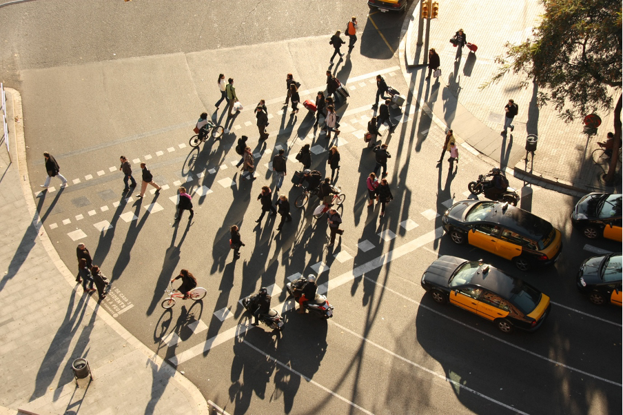
Self-driving cars are a good example. Cars are known to be dangerous to people, and society agrees that cars have to be carefully controlled to avoid injuring or killing people. This is the reason drivers have lessons, are tested, licensed then insured, cars are registered and tested every year, there a set of rules to follow around roads and visually reinforced using signs and road markings.
As a result, the operating systems of self-driving cars are programmed to avoid a collision with someone. And this becomes interesting in cities, if someone steps out in front of a car it will stop or swerve to avoid a crash. While this is consistent with the current social contract that allows cars in cities, it could also have a series of unintended consequences. As Malcolm Gladwell talked about in his “I love you Waymo” podcast a few years ago, if operating systems prevent cars colliding, it means anyone can step in to the road anywhere, it means pedestrian crossings won’t be required, and potentially that cities become grid locked with cars that can’t move more than a few meters before they avoid a collision.
In the BBC’s Digital Human podcast on Utopias, Aleks Krotoski talks about the difficulties that new technologies face in integrating with complex environments. This difficulty has been recognized, however rather than unintentionally creating cities where people have the highest priority, there have instead been over-simplistic proposals to adapt cities around self driving cars – effectively separating self-driving car infrastructure from the complex environment of the city.
This sounds familiar, and is precisely the part to be very careful about. Because the technology struggles to respond to the environment, it doesn’t mean we should change the environment around the technology. We have examples from the last hundred years where over simplified approaches have tried this: from the middle of the twentieth century cities were adapted around cars; urban highways were cut though existing city centres; roundabouts, ramps, under- and over-passes were added so that cars could continue to drive at constant speed; car parks occupied entire urban blocks, large scale infrastructure broke apart a complicated, multi-layered and multi-scaled urban form that had developed over centuries around people.
New towns and cities in the last hundred years were designed around road networks, separating modes of transport, splitting land uses in to individual zones with a cbd, a shopping mall and low density residential suburbs. While these made it possible for people to drive across a city at 60 mph, they also made it impossible to cross the road and walk to the local shops. They made it less easy to walk to work or school and less likely to bump into people then stop and chat.
The unintended impacts of this change have been well documented: traffic in cities worsens air quality and contributes to higher levels of respiratory illness, people who drive to work instead of walking the 5-10 minutes to the bus stop at each end are at higher risk of becoming obese and developing further long-term conditions, social isolation and loneliness is associated with severed parts of cities, vehicle produced emmissions contribute to climate change. Often it is less wealthy, or more deprived communities that suffer these negative effects most. These health impacts have a wider cost to society, and secondary economic impacts, and it is also understood that encouraging people to walk or cycle brings benefits to local economies.
An additional problem is that because the infrastructure for cars is big (and often concrete), it is difficult, slow and expensive to change, which means many cities are locked in to car dependency. In the USA, many cities now are not dense enough to sustain public transport systems.
Projects such as “The Big Dig” in Boston, sought to mitigate some of these issues by burying an urban highway in a tunnel, however despite the positive impact of the project it became notorious for enormous expense and cost overruns (it also didn’t address the underlying need to drive). More recently, approaches such as road diets, and low traffic neighbourhoods have tried to reallocate space from cars to people, and while there are examples where these have worked, they have been controversial and are dependent on the underlying connectivities of the streets that have been redesigned.
Cities as complex systems
Where the successful businesses mentioned earlier are interesting is that they have adapted or optimised existing business models that are already embedded in cities. Deliveroo only works where there is a large enough group of customers, close enough together, and easily accessible from existing restaurants. There have been innovations around things like dark kitchens to supply areas where there are no restaurants, however these have pushed into issues around regulation, and again are only viable in parts of the city where there is a large enough addressable market.
So if we want to know how to adapt technology around cities, we need to explain and understand how cities work. To start to do this we can think of the city as a complex system that combines parts, or sub-systems.
Within cities, emergent effects can seem to happen by themselves; traffic jams occur in certain places, house prices vary between different neighbourhoods, similar businesses cluster together in certain parts of town. These emergent effects are a characteristic of complex systems.
There are many sub-systems in cities; layers of policy, multiple stakeholders, the built environment, mobility services (e.g. transport), bio-diversity networks, legal regulation etc.
Some of these sub-systems are invisible, and change at different rates ot each other. So too do the visible, emergent, effects meaning it can sometimes be easy to focus on an emergent effect rather than the properties of a sub-system that contributes to it.
This might sound intimidating (and impossible) to intervene in, but some sub-systems are more influential than others, and can be changed by certain stakeholders – planners, urban designers and architects for example have influence over the built environment. If we are able to change these parts we need to understand how they work and their potential impacts.
The work of Bill Hillier developed space syntax techniques to consistently describe, then analyse a part of the built environment – spatial networks. There are many interesting parts to Bill’s work, from a set of theories that explain how society constructs spatial relationships in particular ways which then feed back to influence society, how spatial networks can be converted in to nodes in a relational graph that can be analysed in terms of connectivity hierarchies (across different scales), and explaining how these hierarchies affect emergent effects such as distributions of movement and certain land uses.
Perhaps the key point though, is in the translation and analysis of datasets in a graph, using a method which reflects the way that people see, physically move through and cognitively understand spatial networks. This is important because it is not a technological interpretation of space in cities, but a technology adapted around people’s understanding of space in cities.
These techniques can be used to compare different cities around the world, as well as to look at the hierarchies of space in individual cities. One of the consistent key findings is that cities that perform well have spatial networks where the same spaces are well connected at multiple scales. This means that the spaces that people use without thinking about, are the same for short, local journies as they are on a wider journies across the entire city. Consequently, some spaces bring together different people in the same space at the same time, creating opportunities for chance interaction – people can come into contact with people they don’t already know, or haven’t arranged in advance to meet. In turn this creates opportunities for economic and social activities. In cities designed in the latter part of the twentieth century, which often prioritised the car, it can be seen that their spatial networks do not have this multi-scale characteritstic. Typically in these cities, at the wider scale a different set of spaces are strongest and tend to be used by more traffic, while a set of isolated local areas are fragmented from the wider city.
So what this shows is that the cities that developed over time, at the scale of, and around the needs of people, have created spatial networks that are identifiably different. Adapting the design of cities around the technology of the car mean that these spatial characteristics were not included, and this is associated with the negative outcomes set out earlier.
Linking back to the idea of the city as a complex system, we have to caveat the influence of the spatial network. Because cities are complex, and outcomes are a combination of a whole series of factors (for example health outcomes such as obesity are also affected by factors such as age, income and lifestyle), we cannot guarantee that putting a particular kind of spatial network, or built environment, in place will create a particular outcome. However, what it can do is to make it possible.
Because the spatial network is heavy infrastructure, and is also embedded in land ownership (i.e. to change the alignment of a street requires negotiating with many land owners, then paying to buy the land needed to re-allign the street), it is difficult and expensive to change, which means that we are locked in to it for a long time. If it is designed in a way that makes people car dependent, where there is nothing to walk to, and the distances between things is increased, it can make it impossible for people to be active everyday and make positive outcomes very unlikely, if not impossible.
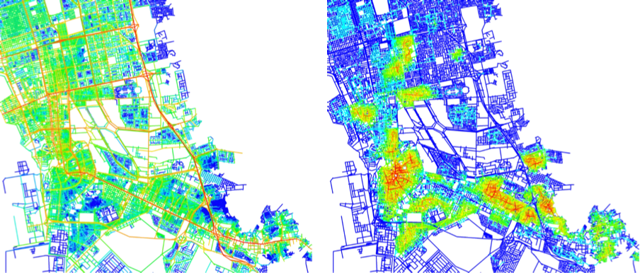
Image: Space Syntax
Can technology help cities?
So a magic bullet new technology to address all of our problems may be unlikely, but new technology does bring opportunities. New technologies generate new data, and this creates chances to improve the way that cities work, by being able to see what actually happens and then to respond – this is the premise of smart cities and digital twins. However, to do this we need to be able to position new data to understand what it really shows, and how it fits in to the way cities work.
The previous section outlines how complex city systems are formed from sub-systems, that these sub-systems produce emergent effects, and that over time these emergent effects have long-term impacts. To understand how a sub-system contributes to an emergent effect we need data on both the sub-system and the effect.
For example, many devices have the capability to record and send time stamped data on their location. This data can be aggregated by providers (such as phone companies) to protect individual privacy, and can give information on things like traffic speed or number of pedestrians in a part of the city.
Without going in to detail on the limitations of this data (whether it shows numbers of people or phones connected to cell towers, whether the market share is skewed in that city, or how it is located in dense urban areas, for example) this data is useful, because it is data on the effect. It shows What is happening, Where it happens and When. For example, 3,000 people are on x street at 9:00 am on Thursday.
However it doesn’t explain Why they are there, and to understand this we need to understand how the sub-system itself is structured to make certain effects more likely in some places than others.
The chance of successfully changing the way a city is used without understanding Why the effect happens is very unlikely, and is dependent on the implicit interpretation, knowledge and expertise of the individual looking at the data.
To explain Why the effect occurs, we need more information about the sub-systems, and especially the sub-systems that we have influence over.
For example, x street may be busy on Thursday morning because it is the best connected street for pedestrians, it is close to a metro station and is populated by a high number of employers. Even using Ai and machine learning techniques, if the relevant sub-system dataset is missing from the model or the training data, it won’t reliably be able to explain Why things happen, which means interventions to address a problem are unlikely to work.
And while wider knowledge generated by research explains how sub-system structures and hierarchies typically relate to activity is helpful to understand general relationships, linking the sub-system analysis to effect data allows us to see what is happening in the specific place.
There are therefore opportunities for developments in technology to help us understand cities better so that we can shape an intervention, or improve an existing service, however this is a different proposition to that promoted by many companies offerings products such as autonomous vehicles or delivery drones. It also requires knowledge as well as data and tools.
Adapting new technologies around cities (and people)
Applying Bill Hillier’s theory on the social logic of space, the societal structuring of spatial networks reflects a core role of cities to enable and encourage opportunities for (social or economic) interaction in agreed spaces.
Adapting cities around the technology of the car provides a useful lesson, namely that if the role of cities is to encourage and support human interaction, we should be planning future cities in a way that encourages this, not in a way that makes it easy for the technology to be deployed. When our cities work badly they exacerbate some of the problems of our current time; climate change, the physical and mental health crises for example. In many cases this happened because the city was simplified and re-prioritised around the technology of the car, rather than adapting the infrastructure of the car to work with the intricate, multi-scaled, spatial networks that support people.
New technologies have the potential to help address major challenges, but they must do this without losing cities’ positive characteristics, and this means adapting technology to work in the complex environment of the city, around and for people. New data generated or captured by tech innovation could be produced and analysed faster, or in new ways, and this may be the big opportunity for technology to improve cities. Even this though needs to be done considering the way cities are structured, how people interact with them, and how the data itself reflects this.