Simulating movement to generate emergent urban form

Introduction
The work of Bill Hillier has shown that patterns of urban form and movement are intrinsically linked. These patterns also influence the distribution of land uses, land values and density across cities: the structure of spatial networks encourage movement to and through some areas (these tend to develop as places of trade or exchange), and discourage movement from other areas (these tend to be more private residential areas). Because the spatial structure influences so many characteristics of a city, the right structure can make it easier to ensure the social, economic and environmental sustainability of a city.
As urban function has such strong requirements for movement, the ability to simulate movement and use this to generate urban form could be very useful, especially in rapidly growing cities where layouts can be generated quickly and land uses/densities distributed where they will not need major change at a later point in time.
This piece shows the results of an experiment to test the outcome of a generative design approach that uses simulated movement from a wider urban context to generate an urban form.
Urban form and movement
In the paper “Cities as movement economies”, Hillier demonstrates that the organising element of a city is spatial configuration: configuration influences movement which creates opportunities for interaction and therefore trading, socialising, and security. If spatial configuration can be modelled and related to existing movement patterns, it follows that these models can be adapted to a proposed design to predict future movement patterns. The design itself could have been developed according to any set of principles that may or may not have been followed rigorously or objectively.
The development of “agent” simulations means that now, rather than using one process to design, then another to test and predict the outcome, a single process could potentially be used to develop a design from the movement patterns created by emergent agent paths. Agent simulations tend to be used at the micro-scale of analysis, the aim of this experiment is to test how successfully these techniques can be adapted to a larger scale to mimic some of the physical processes that occur as cities grow organically.
Why develop an emergent process?
Cities are complex systems that combine multiple components and structures. Some of these components generate effects in other components, and some are dependent on others for their own success and/or sustainability. It could be argued that many of the problems affecting cities today are the result of poor planning or design decisions. To take a few examples, land use zoning, the over pedestrianisation of space, and traffic focussed planning have all contributed to phenomena such as doughnut cities, slums, segregated communities, increased energy consumption, high car use, and congestion. One contributing problem is that without understanding the hierarchies and dependencies between urban components, it is unlikely that isolating and considering each in turn will lead to success.
It is true, that planning is vital to delivering the infrastructure networks that supply important services, but planning a city form by isolating individual components and developing these components discretely, with no integration with the other components, can lead to the development of major social, economic and environmental problems – the UK New Towns are one example.
Not every organic structure is automatically successful however; it is only those that work well that survive today. Because organic structures develop and are refined over a long time, they have a chance to respond to the way people understand and use space. These are the relationships identified by Bill Hillier, and the ones that need to be understood to contribute to a successful design process. Using an emergent design process will only work if it follows these patterns which have been refined and adapted over time.
If these patterns are understood already, the next question is why can’t they be integrated in a typical/traditional design process? Even if a set of design rules has been developed that responds to the fundamental use of space rather than market priorities, there is almost always a human instinct to change things slightly, however minor; the shape of a connection to make a nicer curve, the outline of an urban block to form a better shape etc. These small decisions can end up changing the entire spatial structure of a design. Using a process which is based on these rules but follows them completely objectively means that these small changes do not happen unintentionally, and that the strongest possible starting point is generated.
The aim of this experiment is therefore to simulate the effect of time without having to wait for the city to correct itself through major interventions. Rather than using this process to generate the finished, it should be seen as an attempt to get more of the major relationships right sooner, and in turn reduce the need for big changes later.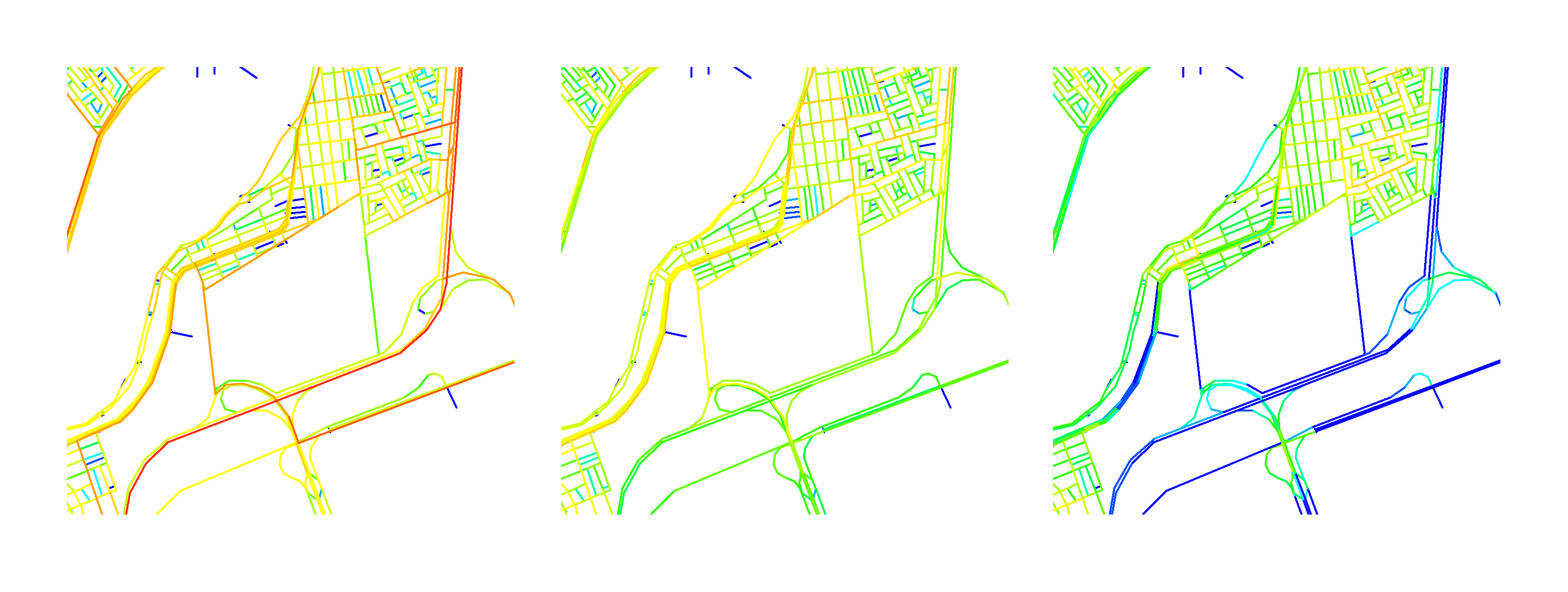
Above: Spatial analysis of the site’s surrounding spatial structure across scales, 10,000m (left), 5,000m (centre) and 800m (right).
Analytic/Emergent/Generative process
The experiment starts with a vacant piece of land in a city with an existing Space Syntax model. It should be stressed that the study is purely hypothetical, and bears no relation to any work currently or previously undertaken by Space Syntax Limited. The site is close to the urban periphery, is defined on one edge by a motorway, and on two other edges by sub-divided, mainly residential areas.
The outline for a route structure was generated through the use of agents. Released from specific points, agents simulate the movement of people and have been programmed to move towards a pre-defined destination according to what they can see of the local network. Different numbers of agents can be released from each point depending on a pre-defined value, and different points can attract more or less agents based on a second pre-defined value. The result of this process is a set of “traces” showing the routes followed by each agent.
To generate the pre-defined numbers for the agent origins and destinations, a different type of analysis was used. A segment model of the existing city identified the key connections into the surrounding network at different scales. Multiple scales are necessary as Cities work across a range of scales; the spaces people use to walk 5 minutes are different from those used to cross the entire city, however urban centres often form in spaces which are well used across a range of scales.
By looking at the site as a solid mass, the traces can be carved out as voids. These then form the open space network roughly equivalent to primary/secondary scale routes and public spaces. Smaller routes or footpaths have not been added, but a similar method could be used again to generate these.The resulting spatial structure can then be analysed again to identify which parts are the most well used, and to begin to understand how this might influence functional distributions. Using the theory of the movement economy – that spaces which are more connected collect more movement, attract commercial uses, higher land values and therefore higher densities – it is possible to start to distribute density within the design. By measuring how visually integrated the perimeters of each urban block are from all points within the site, it is possible to measure the exposure of the block as a proportion of the total movement within the site. This value can then be used to inform the three dimensional characteristics of each block, with the more visually integrated edges extruded higher.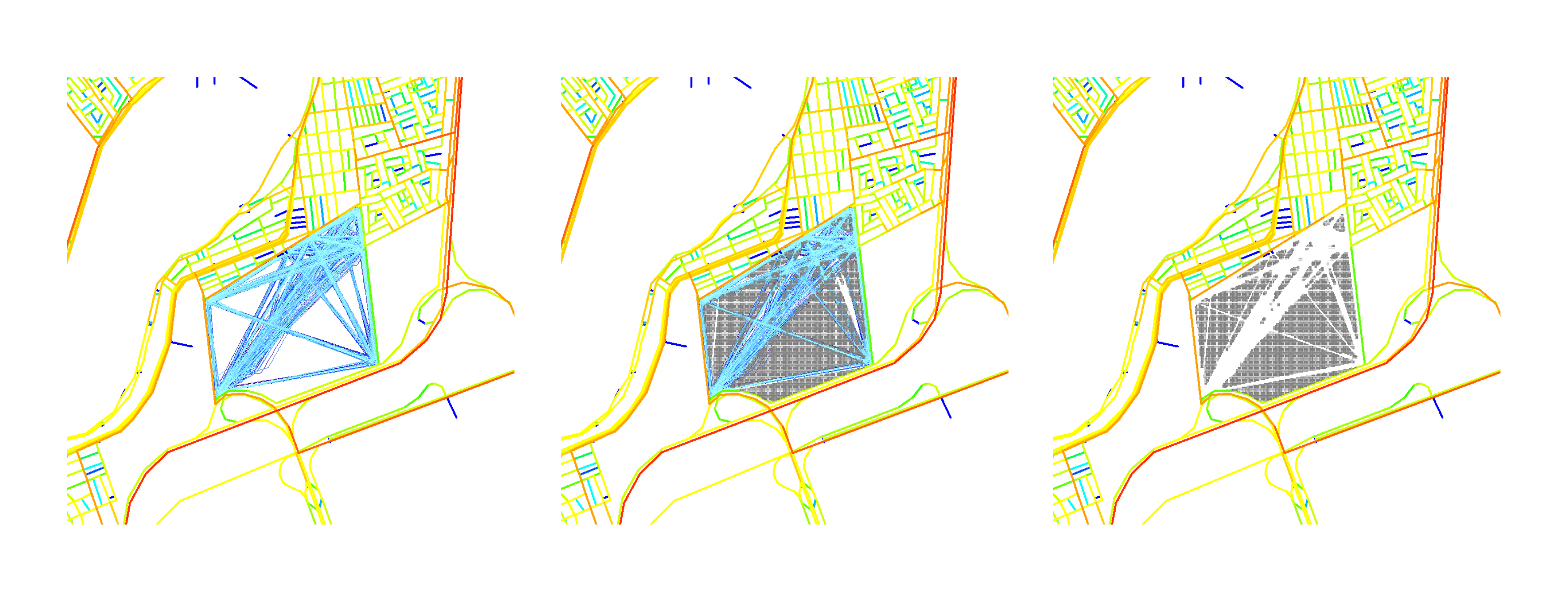
Above: Process of generating urban block structure. Paths created according to strength of surrounding network at different scales (left), paths are then subtracted from solid mass of site (centre) to leave urban blocks (right).
Outcome
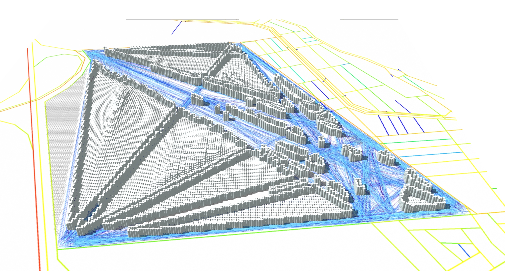
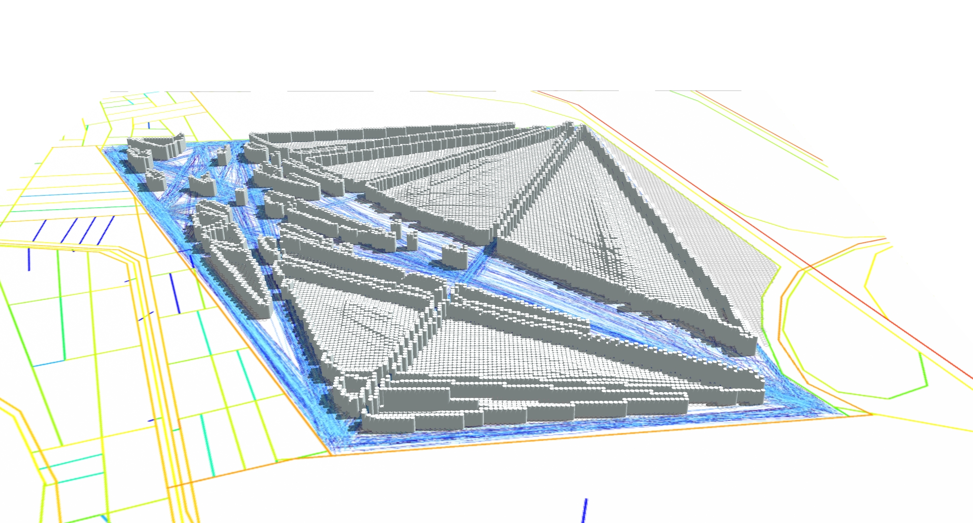
What emerges should be seen as a massing envelope defining block edges, heights and potential uses. The differences between the height at the centre of a block and its edges are a result of the differences in visibility – currently only the equivalent of primary and secondary routes have been defined which results in very large urban blocks. It should be pointed out that the blocks will need to be sub-divided further – which should be carried out using a similar process at smaller scales of accessibility – and once this has happened the presence of connected spaces will refine the massing further.
 There is a spatial logic to the design; connections can be seen linking the most important surrounding routes using differently sized spaces, with the stronger connections also having higher densities distributed along them. The result of the process should not be seen as a finalised design but more of a framework which can be used as a starting point to take account of the smaller scale or dependent design considerations.One criticism could be that using this approach will always lead to the open space developing in a star shape because the model connects points on opposite corners through the centre of the site. This is not necessarily true because it is based on connecting strongest links; if the strongest links are on adjacent sides rather than opposite sides, it should generate a different pattern. The process should create an objective response to the surrounding spatial network – the reason there are big blocks in one corner and small blocks in another is that the surrounding network is more intense in the corner with the smaller blocks.
A second criticism is that this method only responds to one set of constraints, which are spatial. Every design is a negotiation between multiple constraints that include (amongst many others) environmental, topographic, transportation, financial, political, heritage, etc. Currently this process does not take any of these in to account, however the aim of this approach is to define a framework on to which smaller scale decisions can be made.
Through the work of Bill Hillier it could be argued that the most important element of a City is its spatial network which informs many other relationships. The spatial structure of a City remains consistent for hundreds and even thousands of years. Buildings and technologies work over a smaller scale and tend to be replaced individually over time within existing plot boundaries, once the network is established it becomes very difficult to adapt it, and it is for this reason that it should be developed as carefully as possible as early as possible. Cities can only be truly sustainable if people want to use and live in them. Employing a design process that creates the foundation for the large-scale relationships that exist in cities which have been populated for centuries – based around human processes of navigation and interaction – should be the starting point to which other layers of constraints can be added later.
Next steps
Currently, the execution of the design process used here is not very smooth and requires a lot of analytic processing, exporting and importing between different software. One of the effects of this is that all of the data is included within a grid of points which gives the model its cellular appearance at the end. The next step will be to look at using meshes to generate smoother, more continuous forms on a more complex site. Alternatively another option is to work with this quirk of software by using the points in the grid as a base for cellular automata which can then combine or mutate depending on spatial characteristics.
References
Hillier, Bill, “Cities as Movement Economies”, 1996
