A different approach to measuring density – part two
This post works through two examples to make a case for measuring density in terms of population per length of street rather than population per unit area.
It uses two different building typologies to distribute people. While these are typologies rather than measures of density, they are important because they are often how higher level, block-based densities get interpreted and applied at the scale of the urban block.
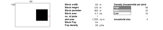
In both cases a consistent block size and population have been used. The variation comes from the way this population is distributed at the block level (through individual buildings on individual plots, or through a single building on a single plot.
These two approaches have then been distributed across a grid of streets, and compared in terms of the number of people who live on each street. While this is a very simple measure – it does not consider the people who may be passing through the street as part of a larger scale journey – it does give an impression of the latent activity that could occur.
Typologies
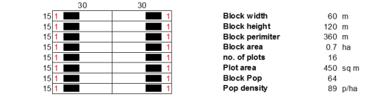
The multiple plot based approach is below:
The single plot approach is as follows:
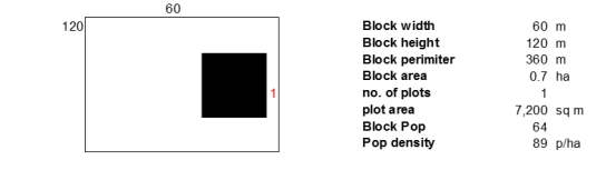
The assumption behind this typology is that there is a single entrance to the plot located in the edge closest to the building.
Urban impact
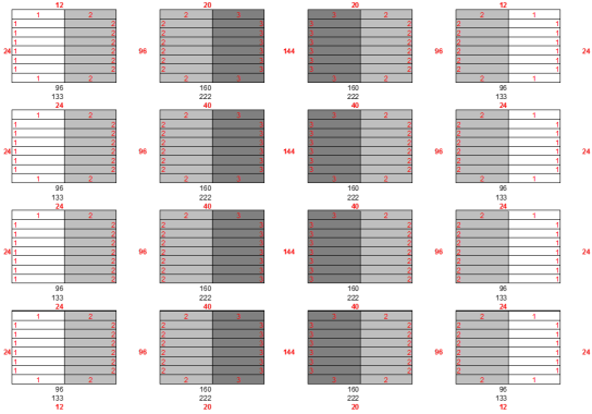
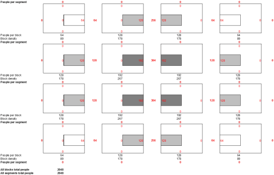
To assess the impact of these approaches, they have been applied across a simplified grid, 4 x 4 urban blocks or 5 x 5 streets. To compare them, the number of people per street has been calculated based on the number of households (although this could be a population for any use).
To look at the impact across a slightly larger scale, some variation in multiple or single occupancy buildings has been used. While the numbers per building differ between approaches, at the scale of the urban block they accommodate the same population.
Following the same overall pattern of density gives the two following options (the numbers in black give the population and density per block. The numbers in red give the total number of people per street):
Multiple plots

Urban impact
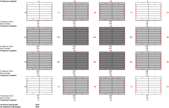
Single plots
Urban impact
Comparison
The clearest differences occur in the number of people per street. The total and average number of people per street are the same in both options.
Within the multiple plots per block approach the range of values is smaller (132), with a lower maximum (144) but higher minimum (12).
Within the single plot approach, the range is larger (384), with a higher maximum (384) but much lower minimum (0).
On the basis that people per street brings many benefits in terms of natural surveillance, opportunities for economic interaction, sense of urban buzz etc, a figure of 0 must be considered negative.

If these figures are looked at in more detail through a frequency distribution, then the difference becomes even greater. The most commonly occurring result (Mode) in the Block based option is 0, in this case meaning that 70% of the streets in this option have a population of 0.
Conclusion
This should not be seen as a criticism of tall buildings which are sometime used to accommodate density in this way, but as a criticism of the way large plots can be designed poorly to result in blank and inactive frontage.
Because the multiple plot approach creates no streets where there are no people, it must be considered a better approach.
Currently this comparison has been made on the same hypothetical grid structure, but to transfer in to practice, a version needs to be developed that is comparable between cities and parts of cities. This can simply be done by normalising the values by the length of the street to give a population per m.
While the measurement of density itself as a block based unit does not itself create car-based urbanism, it leaves space for it to develop by not defining precisely enough how density is distributed. Good urban designers, architects and planners can take this simplified approach and create street-based urbanism, but there are also a lot that don’t.
Introducing a street-based measure of density leaves less room for mis-interpretation or less need for additional design guidance, while also creating a unit that can be aggregated up to the scale of a block or a city.
