How can we best collaborate to improve personal mobility?
These are the notes from the session I was part of at Friday’s Digital Transport Exchange.
How can we best collaborate to improve personal mobility?
There are two issues behind this question:
Firstly, that personal mobility isn’t as good as it should be. This is one of the big issues that’s raised a lot at the moment all around the world. Especially how the combined costs of mobility and housing is pushing people further out of cities and/or detrimentally affecting their daily lives.
This is not just an issue about how to provide mobility services, but it’s a wider issue around a planning and design.
Secondly, collaboration is not as good as it should be. This includes sophisticated disciplines working in parallel, differences between public and private sectors, short- and long-term decision makers, and divisions within large organisations. The result of this is that the outcomes of design, planning and service strategies optimise individual systems rather than creating combined outcomes that benefit the wider city.
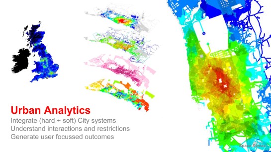
By using urban analytics that are strategic in nature, precisely link people to space, and focus on outcomes not systems, we can start to address these issues.
So how do Space Syntax start to address this?
To provide 30 second introduction to Space Syntax; we’re an employee owned company that spun out of UCL over 25 years ago.
The company started with the aim of taking a developing technology that allowed modelling and analysis of spatial networks, and applying it to real world projects to create better cities.
Urban analytics
Over the last five years or so these analyses have been able to combine bigger datasets covering a wider range of urban systems. This is partly because of improvements in hardware but also the result of the amount of open data and open source software available.
What these more complicated models allow us to do is to see how different infrastructure systems – the street network, public transport, density and land use – interact with each other and where these create certain opportunities or restrictions.
Slightly counter-intuitively, these more complicated models allow more simple analysis to be generated – that is analysis that requires less interpretation.
These analyses can be focussed on the needs of a particular user, things a resident might be interested in – such as what the choice of schools within walking distance is – and to be able to show how this varies for every household across the city in the way a policy maker can get an overview.
And on one level the question might be so what? We’ve known for a long time that there are parts of a city which have better or worse access to services, and how to measure this, but where the big changes have come is to be able to combine this with open data. This makes it possible to say how many of those schools have suitable class sizes and get good results. And to go further than this, to include demographic data to see where the more disadvantaged population live to see how access to good services can be improved for them.
So these new analyses allow us to see where there are restrictions created by infrastructure, and to see where this overlaps with areas of disadvantage.
How can we use these models and analytics?
These are quite strategic level structural models. They’re not agent models that deal with interactions between people or vehicles, but instead they expose an underlying set of hierarchies.
There will be limitations around the exact outcomes of these models, but they generally create good correlations. Because they’re strategic it means they can be made and changed quickly.
This means that there’s a tool that can be used during the planning and design process, firstly to provide a lens to examine existing conditions – and to think about how outcomes are affected by infrastructure systems – but also to provide something that can be used to rapidly test design options.
Because there are assumptions and limitations, we know it won’t provide something that replicates outcomes 100%, but it can supplement the current design process that tends to use detailed models later in the process when there are fewer things that can be changed, to become an integral part of the process.
So by supporting and developing design and planning practices, it means we can start to answer the first part of the question about improving mobility: by planning cities better.
How is this useful during day-to-day operation?
It’s possible to take the outputs of the same model and use it to make shorter term decisions. Because the model can be tuned to look at different outcomes, it’s possible to look at something like how car dependent every household is.
This is the restriction created by infrastructure systems. Linking this back to socio-economic data is where this starts to get in to the questions around how services are delivered.
There will be demographic groups with the ability to pay for personal transport, who can overcome the infrastructure constraints, but there will also be groups that will find this more difficult.
It means discussion can be around more sophisticated pricing models based around subsidising transport from some areas, or improving service levels, or creating new routes, or targeting new semi-public services.
By collecting the data on how these things work, it also makes it possible to build up a richer data set that can be fed back to the earlier stages to improve on the initial open data model.
How can collaboration actually deliver the benefit of these potentials?
And now the second part of the question, which is the really tough part.
Tech provides huge potential to be able to optimise combined outcomes rather than individual systems, and to make better longer term strategic decisions using rapidly collected or live data, however it can’t do it only through a technical solution.
It needs a shift in the way very specialist and sophisticated disciplines and professions work together and share approaches, it needs a shift in the way that things are procured, and it needs agreement between public and private sectors to share and use data (and the standards that allow this).
However if we can do this there is a huge potential to make cities better and deliver many wider benefits.
Image (C) Space Syntax 2017
Words by Ed Parham
