The potential of new mobility services to overcome poor planning in a socially responsible way
This is the summary of a talk I gave recently at a Mob Ox event in Oxford. It picks up some of the ideas in this post about Uber, and is especially relevant in relation to Waymo’s recent announcement.
It focusses on some work we’ve been doing to understand how infrastructure and land use interact in cities, and uses this to frame the conversation around these mobility services
In the last 50-60 years we’ve been designing cities for cars (instead of cars for cities) and as a consequence we haven’t been designing cities for people.
One of the outcomes of designing infrastructure in this way is that it makes certain behaviour/transport choices impossible – or at least very difficult.
It’s arguable that some of these ideas can be traced back to the garden cities, but the focus on the car really started around the 1960s.
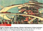

Looking back on some of the ideas from that time, they seem slightly outrageous, but some of these ideas can still be seen:
The UK new towns created movement networks that were split by mode – there are a set of dual carriageways for cars, and a set of paths that go through green space for people. Land uses are split so there’s a centre with retail – in this case it’s actually a shopping centre (that closes), and this is separated from discrete clusters of residential use.
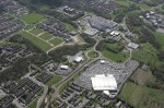
Often, residential use is low density and arranged around cul-de-sac type street layouts. These make the distances between things further. The dual carriageways (for driving along fast) are difficult to cross, and these create barriers around the residential areas.
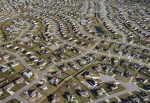
This type of approach is followed around the world. There are some amazing and terrifying images of sprawl in the US. Again following the model of single use, low density, culs-de-sac.
And, although it’s widely known there are problems with it, the approach is still followed on a massive scale. This time in the Middle East, with large, isolated, typically single use developments based around motorways and culs-de-sac.
Why does this matter?
Research from the US shows how the cost of public transport gets more affordable with increases in density. For public transport to be viable there is a threshold minimum density.
In the last hundred years though, the proportion of people living in US cities at the density to support public transport has dropped substantially, on average from around 90% to below 20%.
Over the last 40 years, there have been significant increases in Obesity.
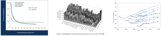
These are US examples, but in the last year there have been papers in the BMJ linking lower levels of obesity with use of public and active transport. More recently, the Lancet published research identifying associations between obesity and lower densities.
So is the answer to increase density? Not by itself. Just making density higher, or providing a public transport network won’t work by itself. These systems need to be integrated with each other, and the wider city to work properly.
There’s a note of caution here around correlation and causation, and just because systems interact in a positive way it doesn’t mean they will definitely create a certain outcome, i.e. more active transport and lower obesity levels. It does however make it possible to walk, which is something that car centric planning doesn’t do.
How can these systems be integrated better?
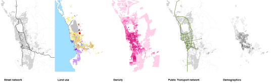
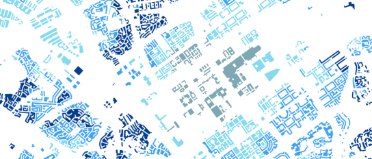
By using integrated urban models, it’s possible to see at a strategic level how these systems interact with each other. By combining four key systems – the street network, land use, density and public transport – it’s possible to start to do this.
Demographic data can also be added, which becomes useful at a later point.
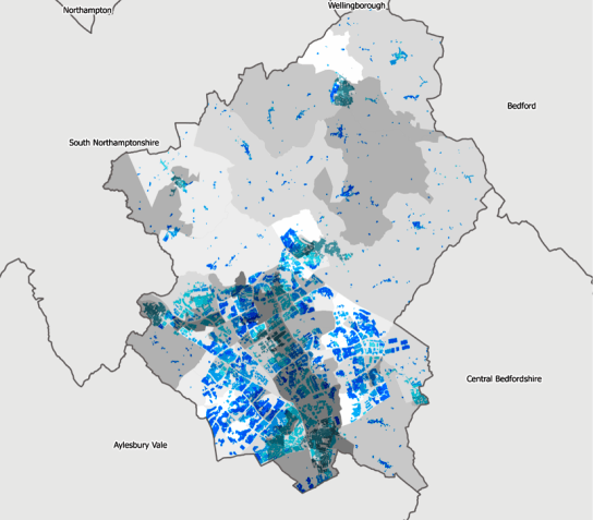
Car dependency
Using this model it’s possible to calculate a measure of car dependency at the level of the individual household. What this shows is the ratio of jobs within 30 minutes by car against jobs within 30 minutes by active and public transport.
If you live in a dark blue area, the advantage of having a car is five times not having a car. This data can be looked at as a set of maps or as more statistical distributions.


If, for example, a city wanted to increase its public transport mode share, (which aside from bringing health benefits would improve air quality), then ideally these two peaks would be closer together.
Linking in demographic data to the model we can compare where the model says people are more dependent on cars, as a result only of the infrastructure, against commute to work data in the census.
So what?
If people can afford to own a car and drive to work, or drive to the gym so they’re healthy, then isn’t this an individual life style choice for them and does it matter?
Yes, it does matter. Firstly, it’s not a free choice, the infrastructure of the city is biasing decisions. So even if people wanted to walk to work, they would probably have to be quite determined to do it.
Secondly, not everyone can afford a car to drive to the gym, or maybe there are older or disabled people who can’t drive.
And finally, more people in more cars is worse air quality for everyone. And typically the places where air quality is worse are where higher density, lower-income communities live.
Using demographic data, we can use risk stratification models to see where more vulnerable people are likely to be, and then compare this to how dependent on having a car they are.
Over the last couple of years we’ve been working with the Future Cities Catapult and made an implementation of an Age UK model that looks at the risk of social isolation in elderly people.
Where the darker grey colours are there is a higher risk of social isolation.
So from this it’s possible to see that there are places where there is both a higher dependence on cars and a higher risk of social isolation. And these should be the places for cities to think about.
How could not owning a car be less of a disadvantage?
Each element of infrastructure could be changed, and the model can analyse how these changes will affect outcomes. However making these changes is often not easy:
The street network carries traffic, utilities, and is embedded in land ownerships – it’s therefore expensive, difficult and slow to change.
Land use can be changed through planning policy, but it takes time for these changes to be executed on the ground.
Ibcrasing density can be a contentious issue where local politicians are sometimes not keen to promote it.
Public Transport is only viable if the densities are right and the street layout is right. A city full of culs-de-sac is very difficult to plan a route that doesn’t double back on itself.
Getting these infrastructure systems right is really a one-off chance at the point they’re designed.
So what can be done in existing cities?
To end on a positive note, some of the new mobility services and models have the opportunity to address these issues in existing cities. Because these essentially don’t need any new infrastructure they can be implemented easily, by the private sector.
However, if these are to be delivered by a private company there is an issue around how affordable these services are to the more vulnerable sections of population. These services should be offered in a progressive way, so that people living in areas of high car dependence and high risk of social isolation, or maybe in areas of high IMD, could have the cost of their journies offset against those from other parts of the city.
This gives a city a negotiating point when responding to a license application from a company like Waymo or Uber. Maybe licenses could only be granted on the basis that journies are subsidized from high risk areas– or ideally free.
This also gives a starting point to address some of the wider issue of the lack of a social contract between big tech organisations and the cities they operate in. A huge amount of data is collected on how cities work, on top of which products are made and sold, however none of this benefit flows back to the city. Perhaps new models of mobility and autonomous ride hailing services offer a way to redress this balance.

Pingback: future of the city/city of the future | Urban D.A.S.