Introduction
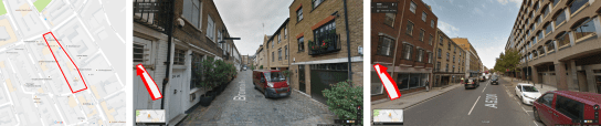
The work of Bill Hillier has shown that patterns of urban form and movement are intrinsically linked. These patterns also influence the distribution of land uses, land values and density across cities: the structure of spatial networks encourage movement to and through some areas (these tend to develop as places of trade or exchange), and discourage movement from other areas (these tend to be more private residential areas). Because the spatial structure influences so many characteristics of a city, the right structure can make it easier to ensure the social, economic and environmental sustainability of a city.
As urban function has such strong requirements for movement, the ability to simulate movement and use this to generate urban form could be very useful, especially in rapidly growing cities where layouts can be generated quickly and land uses/densities distributed where they will not need major change at a later point in time.
This piece shows the results of an experiment to test the outcome of a generative design approach that uses simulated movement from a wider urban context to generate an urban form.
Read More