How should the cities of the future be designed?
These are some notes from a talk I gave at Space Syntax’s last Urban Imperative: Improve, Extend, Create series of events in July. It looks at how to think about designing a city from scratch. The focus of this post is to look at exactly which components of a masterplan to design and why.
This shows some work that is slightly experimental. At the moment it’s about testing ideas through a process, and at the moment it’s only a process. It started as a real project to look at ideas about how to develop a city from scratch but then some further research work was done.
Vision vs Outcome
The start looks at a few general planning and urban design trends from the last 50 years or so and asks why they didn’t work as intended.
This picks up on some areas I’ve written about before, and rather than make the same arguments again I’ve linked to them below.
These include discussion on why approaches to planning and masterplanning in the last fifty years or so haven’t worked, and what could be learnt from looking at unplanned and informal settlements that emerge by themselves.
While some of these approaches – such as garden city based thinking which creates low densities and single use zones – are recognised as failing, they are still being used. A lot of major development in the Middle East, Asia and America still follows a very similar approach.
Because building large development takes time these designs become sensitive to the wider economic and political conditions. These move in faster cycles than cities. It is a core characteristic of cities that they are big and slow, complex and expensive to change.
This difference between the cycles of city making, economics and politics creates risk to investors. One response to this is to try to model potential scenarios in order that returns can be calculated and profits generated. The components of these models include design elements such as land use, density, GFA, construction cost and returns on investment.
Many models are based on making back the cost of the project in a timescale that is very short in comparison to the time scales involved in cities. Because the time to deliver large projects doesn’t align with financial or political cycles it can result in designs delivering too much or too little development, being partially completed or even abandoned.
The second response to this is to try to control as many design variables as possible, and this results in the Mega Architecture approach – where masterplans are designed as complicated interlocking systems that are all dependent on each other – but which does not adapt well to a changing wider context.
There is another issue in here (to unpack somewhere else) about enabling land value capture over time in a different way, so that the cost of infrastructure is less of a burden on project feasibility.
So to summarise, in response to a range of conditions, a lot of urban scale design is produced to quite a high level of resolution and consequently not very flexible.
In contrast, unplanned settlements grow by themselves over time. Sometimes growth speeds up, sometimes it slows down, which indicates it can respond to changes in the wider conditions. Unplanned settlements have issues that need to be addressed, however it is worth spending some time looking at how they grow, and which elements enable this flexibility.
Unplanned Settlement growth
Here are two examples of unplanned settlements, both emerge over a period of around 10 years. One is almost completely organic, while one is actually structured but emerges in an informal way through small-scale development.
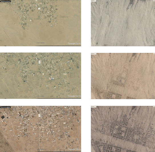
Example 1: Jeddah (left)
In the first example, it’s clear that there is an existing spatial network that is already established. The reason this follows the particular route it does isn’t clear; it may be because of local environmental conditions – the paths that link wider scale destinations using the land that don’t flood or isn’t too steep.
Over time development occurs around these routes. When this development starts there are no (physical) restrictions on where can and can’t be developed. Interestingly though development doesn’t block these paths at any time.
What these images show is the way that what is often referred to in space syntax literature as the “the foreground” network of space is intensified over time by a “background” network of space. A paper in Nature a few years ago documented this process occurring in norther Italy as a rural region urbanised, organically, over time, and identified a similar process.
The network can be described as doing two things – distributing movement through the foreground – and intensifying development through the background. I’ve written in more detail about this before.
This process is interesting for a few reasons that go against typical planning arguments – development is delivered from the spaces backwards, delivered at the smallest level of the plot, and forming blocks that don’t have to be square.
Example 2: Trujilo (right)
In the second example, properties are developed individually over time. This happens within a clearly defined spatial network, although the roads are not surfaced and there is no public realm. This indicates that there is a plan or an ownership system in place that structures development.
Over time, as parts of the city fill in, infrastructure is delivered; utilities are provided, roads are surfaced, parks added. This approach is sometimes called reverse urbanism.
Peru has unusual urbanism where a lot of development is self built, or very small-scale. However, it is arguable that this is the way that most of the world’s rapidly growing cities will develop over the next few decades.
Informal growth as a development model
One of the aspects that is so interesting about informal and unplanned settlements is that they offer a different model of development which is highly flexible. Many properties are self-built and this allows settlement growth to accelerate or slow down in response to the wider context.
It is also made by individuals which means the resulting urban form is often human scale.
So if we come back to the question of flexibility; if the spatial network (and the plots that are the inverse of this) are defined, it starts to create the beginning of a flexible framework that can be filled in over time and respond to changing economic and social conditions.
These two examples provide interesting characteristics to try to combine. The spatial network is very important: it is highly influential on the way the city works, once established its very difficult to change, it (eventually) carries infrastructure and utilities. It should be thought of as key infrastructure.
However, because space is defined by the buildings around it, until streets and spaces exist they are very difficult to define and protect. So in order to protect space, land ownership needs to be defined. Land ownership is also very important as it is very difficult, slow and expensive to change.
It is also important in relation to unplanned settlements. Extra legal, illegal, or insecure tenure is one of the UN’s defining characteristics of a slum. Providing clear ownership patterns from the beginning of development, along with transparent access to land ownership registers, could help alleviate problem this later.
So, this would suggest that two of the most critical elements to define in plans are the spatial network – a set of centre lines – and land ownership – a set of plots.
The first creates development in a way that it can emerge over time, with street based urbanism and a clear spatial hierarchy. The second allows many individuals to develop plots within an ownership framework.
Planning as a framework for growth
So these two elements start to set out the components of a framework for growth:
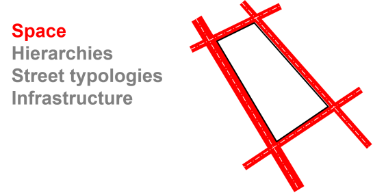
The spatial network can be defined as a set of Centre lines. These can be analysed spatially and developed in to a set of typologies that define streets, alignments for infrastructure and utilities.
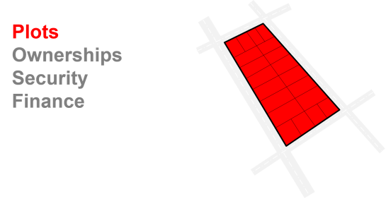
Defining Plots, creates the potential to provide a framework to coordinate small development. Plots (not urban blocks) will later be assigned characteristics based on their edges, meaning that they respond to specific local spatial characteristics.
By defining plots it can help provide security of tenure by making ownership transparent it provides a mechanism for the city to raise income through value capture, and it allows the individual to raise finance against them.
The scale of the plot is important, but smaller plots should be defined as they are more flexible. They can be developed individually or consolidated into larger plots.
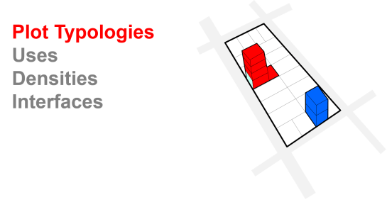
Once plots have been defined, their location can be analysed, and a set of plot typologies can be defined. These would define potential land uses, and densities, based on the characteristics of how these are distributed through existing cities.
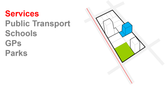
When plot typologies are defined, and the distribution of people is clear it identifies which services are required where. For example, schools, GPs, parks can all be located in the most suitable places.
Summary
 So to summarise what this approach tries to do is make plans that are more flexible, and to do this by planning the fewest number of fixed elements. Effectively this creates a plan as a framework to accommodate growth rather than a plan to be built in large phases.
There will be a follow-up post explaining how it can be generated, but because it can be generated in a repeatable consistent way, it means it can be adapted if something changes, such as land ownership, or more detailed information is found for example .
Because the approach and the process of generating it have been based on analysis of how cities work, it means there is a greater chance of understanding its outcomes in advance, rather than building it and seeing what happens.
Ed Parham 2017
