Archive

Analysis

uk_model.png

This is the combination of a couple of talks I’ve given in the last few months to the ULI Urban Tech Committee and the Academy of Urbanism Digital Urbanism groups.

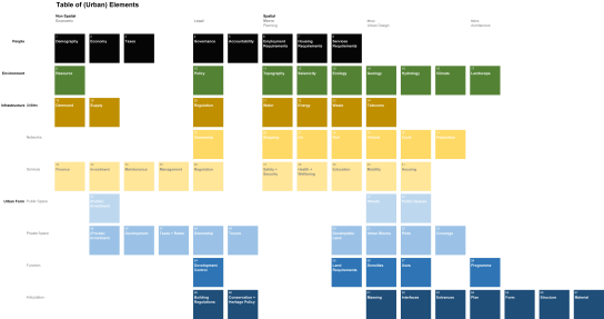
Urban Tech is something that has developed a lot in the last 10 years and which now seems to have a lot of interest and attention. There are a lot of terms – Future Cities, Smart Cities, Prop Tech, Urban Tech, etc – which are all slightly related but not quite connected in the way they could be.

One way of trying to understand how they fit together is by tracing what has changed in this time and what this means for the way we interact with cities.

While its interesting to see how things have changed, what is possibly more important, as professionals who work with, and in the context of cities, is to ask the more difficult “so what” questions of why things should change?

Here’s an outline of the reasons Why that will be explained in more detail below:

  • Better outcomes for cities and people
  • Creating benefits between public and private sectors in the short and long terms
  • More transparent and inclusive decision-making
  • Crossing siloes between planning and service delivery for more effective and efficient spending

Read More

Earlier posts looked at why (master) planning hasn’t worked as intended, reaching one conclusion that the design outcomes weren’t flexible enough. The response was to aim to design the fewest fixed components and allow the city to grow more organically on a plot by plot basis within this framework. Changes in the economic or social context would be reflected by variations in density, land use, massing and speed of growth.

An early outline of fixed components includes solids (blocks, plots) and voids (street, infrastructure, and utility networks). Of course there are a secondary set of requirements that must be provided, but which there is some flexibility in terms of location or exact configuration – these include social infrastructure etc.

This post starts to set out how to develop this spatial framework. Building on Bill Hillier’s idea of the Movement Economy (1) – the configuration of space affects the distribution of people who affects the distributions of land uses and values – the starting point is the spatial network. Space is very difficult to change, with far-reaching impacts, while buildings can be replaced, and land can be bought and sold.

In turn this post becomes an examination into the geometry of spatial networks and urban blocks.

As always these are developing thoughts.

Read More

Foresight_Obesity_Map.png

This post is a summary of a presentation I gave at the BRE Cities Regeneration Conference.

What does health mean?
At the moment there’s a lot of press attention on obesity, but health is much more complex including: communicable and non-communicable illness (Non-communicable  include Obesity, Diabetes, Cardio Vascular, Respiratory and Mental Illnesses), causation and correlation, “hard” and “soft” urban systems and complicated versus complex.

The key question for urban design and planning is: (How) does urban form impact on health outcomes?

Read More

title

This post works through two examples to make a case for measuring density in terms of population per length of street rather than population per unit area.

It uses two different building typologies to distribute people. While these are typologies rather than measures of density, they are important because they are often how higher level, block-based densities get interpreted and applied at the scale of the urban block.

In both cases a consistent block size and population have been used. The variation comes from the way this population is distributed at the block level (through individual buildings on individual plots, or through a single building on a single plot.

These two approaches have then been distributed across a grid of streets, and compared in terms of the number of people who live on each street. While this is a very simple measure – it does not consider the people who may be passing through the street as part of a larger scale journey – it does give an impression of the latent activity that could occur.

Read More

Block 1

This summarises some developing ideas on strategic planning, in particular trying to find a more spatial way to think about density.

Fundamentally density is a way of linking people to space in a way that can be compared within and between cities. However it could be argued that there are a number of flaws in the widely adopted approach, measuring people per hectare, that impact on the way cities function.

Read More

This is a summary of a number of issues around Integrated Urban Modelling discussed in a panel session at the Future of Wireless International Conference 2015. This picks up on a number of issues raised by the Integrated Urban Modelling post but has more of a focus on data.

What are the implications for a fully connected world and how will this impact on the urban landscape?

The opportunity is to collect data at a scale, resolution and frequency that was previously impossible. This means it’s possible to see patterns of movement across an entire city across the whole day. The real question though is how best to use this, and what do we actually need to make cities better?

Read More

001

This is a summary of a number of issues around Integrated Urban Modelling presented and discussed in sessions at the BRE Cities ConventionModelling World 2015, the Future of Wireless International Conference and in the paper: “Integrated sub-regional planning informed by weighted spatial network models: the case of Jeddah Sub-regional system”, (co-authored with Dr Kayvan Karimi and Abhimanyu Acharya) and presented at the 10th Space Syntax Symposium. Presentations can be found on the relevant websites.

Read More